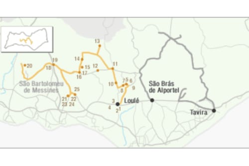
1st leg: Salir - S. Bartolomeu de Messines
The village of Salir spreads its white houses over the hill, surrounding the ruins of the castle. The narrow streets, the whitewashed walls and the flowers of the houses give it a touch of tranquil living. Archeological excavations of the castle assume it was inhabited by the Celts, but it was the Arabs who made it grow during the period of the Almohad occupation in the 12th century. They are the ruins of the Castle of Salir (11), an important archaeological heritage that will soon have available to the public the appropriate infrastructures for its interpretation.
We leave Salir in the direction of Alte on the EN 124 road, but soon turn towards Rocha da Pena (12), an ICN Classified Site and excellent for hiking and extreme sports such as paragliding and climbing. We take road 503 to Cortinhola. Here we take a small route to Malhão (13), where there is an excellent viewpoint over the mountains and a Buddhist temple. Continuing on road 542 we continue to Azinhal where we detour to Sarnadas, in the direction of Alte. The land we cross is part of Quinta do Freixo (14), an agricultural property, with a game reserve, agro-tourism and organic agro-food products. We stop in Sarnadas to enjoy the local gastronomy and listen to Mr. Joaquim, an excellent storyteller. Continuing in the direction of Alte, we detour to climb the 467m Rocha dos Soidos (15), a natural viewpoint with a landscape over the undulating mountain range and with the sea on the southern horizon.
We arrive in Alte, a village with traces of Roman occupation and where the Arab culture has decisively marked the local architecture.
Of the cultural heritage of Alte we must point out the Mother Church (16), rich by its Baroque carving and tiles, the Quinhentist vault, portal and Manueline baptismal fonts and the Church of São Luís. We recommend a visit to the Casa Memória D'Alte, where the local tourist office operates, which has information about routes in and out of the village.
A reference point for any visitor is the sound of the waters of the Ribeira de Alte. There we find the ex-libris of the village: the Fountains (17), Fonte Pequena and Fonte Grande. These water springs, which for centuries moved the nine existing mills along its course and served to supply the local population, are today converted into a very pleasant place for picnics and bathing, as it has a dam in the form of a natural pool.
A few kilometers from Alte, in the direction of Santa Margarida, there is a detour to Torre, where you can visit a cooperative for the handmade production of wooden toys.
2nd Section: S. Bartolomeu de Messines - Paderne
Coming from Alte on the EN 124 we reach São Bartolomeu de Messines. The village is located in a long and fertile valley on the southern slopes of the mountain of Penedo Grande, in the Serra do Caldeirão. The 16th century parish church (18) with a Baroque façade is worth a visit. The contrast between the white of the walls and the red sandstone stonework, the graceful staircase and the richness of the interior make this a well worth a visit. The next destination is the Casa Museu João de Deus (19), where we will learn about the life and work of João de Deus, poet and educator, author of "Cartilha Maternal". Before leaving the village center, it is worth visiting a boilermaker, an albardeiro or a cane basket artisan. The village also has different handicraft stores where you can buy products made of leather, clay, iron, brass, taboo, and rags. To enjoy the surrounding natural heritage we recommend a route following the EN 124 to the Dams of Funcho and Arade (20). There are excellent places for walks, picnics or observing the fauna and flora.
We take the EN 124 again and then the EN 270 towards Paderne. Set against a hill, the village of Paderne is a white manor house that looks more like a nativity scene. Before entering the village, the road signs point to the Castle of Paderne. Halfway up the road we come across a fountain (21) from the 18th century. Soon after, as we begin to climb, we take a shortcut to the right on a dirt track and at the end, just below the large bridge carrying the Via do Infante, we head straight for the Quarteira Water-mill and Weir (22). A pleasant place, with running water, it is a traditional system of milling, whose motive force is the thrust of the water. These mills are older than the windmills and are an inheritance from the Arab period. Following the stream and located further down, in the valley southwest of the Castle, stands the Medieval Bridge (23), Roman in shape, rebuilt in 1771 and where you can see three arches and two carvings with the shape of a triangular prism. From the watermill we turn back to take the road to the Castle again (24). It is one of those shown on the Portuguese flag and was conquered from the Moors in 1248. Classified as Property of Public Interest since 1971, the castle is being studied with a view to its improvement and the areas around the Ribeira de Quarteira are being classified as a Protected Landscape Area. From the top of the castle you can see the water mill on one side and the medieval bridge on the other. There is a 4 km footpath around the castle, the bridge and the water-mill. The whole area is very rich in fauna and flora, but is subject to the proximity of the Via do Infante and the new freeway to Lisbon. We leave the castle by the same road and get back on the EN 270 to continue to the village. We must visit the Igreja Matriz (25), a beautiful three-nave temple, dating from 1506 and with later additions. We continue along the EN 270 to Boliqueime or the EN 395 to Albufeira.